- Platform
PlatformDive into our product portfolio offering powerful Field Service Management, Field Collaboration, and GIS capabilities.
- Industries
IndustriesOver 20 years simplifying mission-critical operations on linear assets, connecting back offices and field workers with efficient workflows, without a single failed implementation
- Customers
- Partners
- Analysts’ Reports
Analysts' ReportsRecognized by global advisory and consulting organizations as a leading FSM vendor
- Company
With the NextGen Platform 2023 Wave Three release, OverIT continues to innovate and address the needs of our customers, dynamically responding to their feedback. This release is heavily focused on field technicians, empowering them to complete their work quicker, accurately, and safer than before. We strongly believe in giving field technicians a “single pane of glass”, allowing them to execute all their work in the field in one single app. From reviewing their work schedule, through capturing data while onsite, to reviewing GIS data and debriefing the job within the same solution. Our commitment to innovation and customer success is the driving force behind the introduction of features that enhance capabilities across Energy & Utilities, Oil & Gas, Telco, and Transportation companies.
Welcome to a world where innovation knows no boundaries and capabilities no limits.
Welcome to the future of FSM guided by OverIT.
This release is another step forward on the road to transforming the way field technicians operate every single day, empowering them to get more work done quicker and without switching between multiple apps.
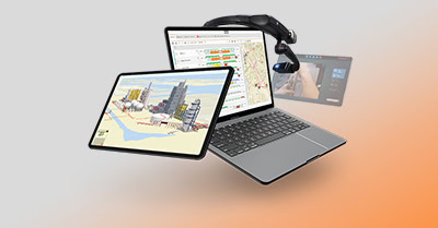
With the new mobile GIS redlining capability, while on the job, technicians can seamlessly capture real-time observations, make annotations, and mark updates and corrections, all directly on the map. This transformative capability bridges the gap between the digital and physical worlds, enhancing communication and precision in the field.
But that is not all. The introduction of an intelligent chatbot on mobile marks a significant milestone in improving user experience. Field technicians, regardless of their expertise levels, can now access guidance on how to use the OverIT mobile app whenever an issue or problem occurs. This real-time support ensures smooth operations, boosts confidence, and speeds up onboarding.
Give field technicians the possibility to capture real-time observations, make annotations, and mark updates and corrections, all directly on the map.
Offer guidance to field technicians whenever questions about the OverIT mobile app arise, providing them with all the answers they need.
The challenge
Technicians often heavily rely on maps and multiple GIS (Geographic Information System) data when working in the field. These maps provide critical information about the locations of assets, infrastructure, terrain, and other relevant spatial data. However, the real world is dynamic, with new infrastructure being built, land transformed, and geography evolved, so that lots of GIS data can become outdated.
- In case of inaccurate map data, a technician might waste time searching for an asset at a location that does not match the one on the map, this resulting in errors during field operations.
- Limited access to the latest updates and changes to the map can result in technicians working with outdated information, potentially leading to errors or inefficiencies.
- Inaccurate or obsolete maps can hinder effective communication and decision-making processes.
- Searching for assets in the wrong location or needing to double-check information due to out-of-date maps can be time and resource consuming.
Let’s suppose that a utility company manages a vast network of pipelines and transmission lines for delivering water, gas, and electricity to various regions. Field technicians heavily rely on GIS maps to track the location and attributes of these assets. But what happens if new gas pipelines are integrated into the network? When technicians arrive in the field, they encounter discrepancies between the map and the actual infrastructure on the ground. This misalignment can lead to confusion, inefficiencies, and potential safety concerns.
The same happens when technicians arrive in the field to inspect wind turbines and discover that the landscape has changed due to recent weather events, leading to shifts in terrain, vegetation patterns, and potential hazards.
Until now, when technicians have encountered inaccurate GIS data, they have needed to document any changes on paper, email, or other inefficient ways and communicate it to the back office for updating. The back office would be required to pinpoint the exact location and figure out what and how to update the data to reflect the current situation in the field. It could take weeks or longer for GIS data to get updated, reviewed, and published back out to the technicians.
The solution
The mobile GIS redlining feature gives technicians the possibility to mark the inaccuracies or changes needed directly on the map, based on what they actually see in the field. They can access the GIS map on their mobile devices and compare it with the actual infrastructure they encounter. If they identify any discrepancies or changes, they can use the redlining feature to mark the updated information directly on the map. So, if a new gas pipeline has been installed, technicians can draw the pipeline’s path on the map and attach relevant information, such as installation date and material used. The updated data is then passed over to the back office for review, significantly improving the time needed to get GIS data updated and back in field technicians’ hands.
Users capture real-time observations, annotate changes, updates, corrections, and notes directly on the map, that can be shared with others. These live updates ensure accuracy, boost operational efficiency, and enhance safety measures.
- Adding annotations, notes, and images to the map to indicate the changes technicians observe. This ensures that the map’s accuracy is constantly being improved and new information is integrated promptly.
- Entering information right at the point of observation directly on the map. This reduces the likelihood of errors and ensures accurate and up-to-date records.
- Sharing annotated maps with colleagues and back-office team, instantly. This facilitates better communication, as everyone involved can access the most recent field observations and updates, ensuring that all stakeholders rely on the latest information to work.
- Enhancing collaboration among field teams, engineering, and back-office staff. Annotations made on the map provide clear visual context to reduce misunderstandings and promote seamless teamwork.
This feature empowers technicians to contribute to map accuracy, revolutionize how they manage and update information on the map, and propel organizations into a new era of efficiency and collaboration, all within the OverIT FSM mobile app.
Impact & KPIs
- Streamlining field operations
- Fostering collaboration across the organization
- Expediting field data collection
- Saving time and costs
Watch the video and discover the full potential of the Mobile GIS redlining feature
The challenge
In view of the ever-changing demands on the workforce, the need to upskill and train new workers on the latest apps and technologies is crucial. Often field technicians need answers on how to use the app and complete the tasks they are assigned to, quickly. This can require calling the back office or another more experienced technician to get answers on where to find the right button, file, or process within the app.
Consider these two scenarios:
- A junior technician of an Oil & Gas company readies himself to execute critical maintenance on towering oil platforms, knowing that safety is paramount. He trusts the power of safety checklists, but soon realizes that he cannot quite remember where to find them within the app.
- A field technician of an Energy & Utility company has recently undertaken a new job role within the company. A demanding week is looming, plenty of electric meter deliveries. Armed with her device, she can visualize what materials she needs to load into her van based on the types of activities assigned.
Unfortunately, she has trouble remembering where to find this information within the mobile app.
How to speed up this process and enable technicians to find the solution themselves, quickly?
The solution
OverIT presents a user-friendly chat built to provide field technicians with all the answers they need. An intelligent chatbot on mobile offers guidance to field technicians whenever questions about the OverIT mobile app arise.
Powered by Natural Language Processing (NLP), this mobile chatbot effortlessly processes, interprets, and promptly responds to any user queries. Technicians can type or dictate their questions at any time or place in the app. No matter the language used, the platform transforms inquiries into real-time answers by providing guidance based on OverIT’s knowledge base and best practices.
- Accessing instant, on-the-spot assistance and guidance on how to find a feature or complete a task.
- Getting new technicians familiar with app features quickly, reducing the time required for training and onboarding.
- Solving doubts rapidly, thus focusing on tasks at hand, optimizing workflows and overall efficiency.
- Ensuring 24/7 support to technicians, whenever they need it and even outside regular working hours.
The mobile chatbot also provides access to official documentation to guide users through an intuitive chat interface. Furthermore, users are asked to give feedback and insights on how they would improve the suggestions made. This allows the mobile chatbot to continuously learn and improve, ensuring that responses are quicker and more accurate.
Impact & KPIs
- Reducing training and onboarding time
- Improving employee satisfaction
- Easing change management processes
- Increasing technicians’ productivity
Watch the video and discover the full potential of the Mobile chatbot feature
THE NEXTGEN FSM PLATFORM RELEASES


We immensely care about the input provided by our customers and we are working to ensure their satisfaction.
Do you want to know more about our initiative?