- Platform
PlatformDive into our product portfolio offering powerful Field Service Management, Field Collaboration, and GIS capabilities.

- Industries
IndustriesOver 20 years simplifying mission-critical operations on linear assets, connecting back offices and field workers with efficient workflows, without a single failed implementation
- Customers
- Partners
- Analysts’ Reports
Analysts' ReportsRecognized by global advisory and consulting organizations as a leading FSM vendor
- Company
Geographic information system (GIS)
Comprehensive GIS capabilities to optimize every stage of your FSM journey
In the utility industry and linear asset sectors, managing complex utility networks, minimizing outages, and responding quickly to emergencies require real-time data from the field. OverIT’s GIS-powered FSM solutions provide comprehensive access to network assets and geospatial data, enabling utilities to digitize networks, streamline operations, and ensure field teams always have the right information, when and where they need it.
CAPABILITIES
Optimizing field operations with real-time GIS mapping data and advanced capabilities
By combining Geographic information system advanced capabilities with FSM solutions, organizations can optimize operational asset maintenance, enhance safety, and improve network reliability. Empower your workforce with tools to extend the entire lifecycle of assets and make data-driven decisions, even in complex network infrastructure.
Unified cartographic view
Access 2D/3D GIS maps, network topology, asset locations, work orders, and resource allocations.
GIS & FSM interfaces
Seamless integration ensures data quality of geospatial and FSM systems.
Always up-to-date map view
Historical and real-time data for asset monitoring and decision-making.
Offline GIS access
Maintain operational continuity even in remote areas with limited network availability.
Dynamic job scheduling
Optimize maintenance and emergency responses using GIS-driven workflows.
Mobile GIS for field activities
Redlining, editing workflows, and on-the-go visualization.
Leveraging GIS and FSM integration to address mission-critical use cases
Linear asset industries use GIS and FSM integration to address some of their most important operational challenges.


Discover key features to optimize your network management with up-to-date GIS data
- Built-in GIS integration
- Augmented collaboration powered by GIS
- Offline mobile GIS redlining
- Network tracing
- Mobile GIS offline extension
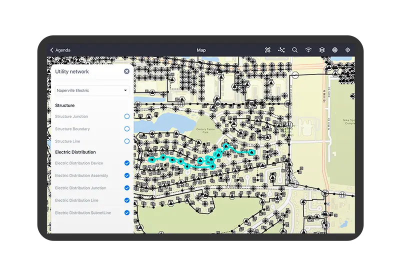
Built-in GIS integration
Enhance network information management systems by interacting with real-time map data and GIS tools to gain actionable insights directly from the field.
- Integration with the daily plan to optimize resources, orders, routes
- Access detailed plan structures
- Offline geographic data and maps
- Map collaboration through bookmarking and redlining
- Network diagrams
- Asset search and location
- Measurement tools & coordinates
Augmented collaboration powered by GIS
Leverage augmented reality (AR) for an enhanced utility network functionality, allowing technicians to locate and interact with real-world network assets in real time.
- Accurate asset diagnosis
- Guided navigation to the asset
- Work order visualization
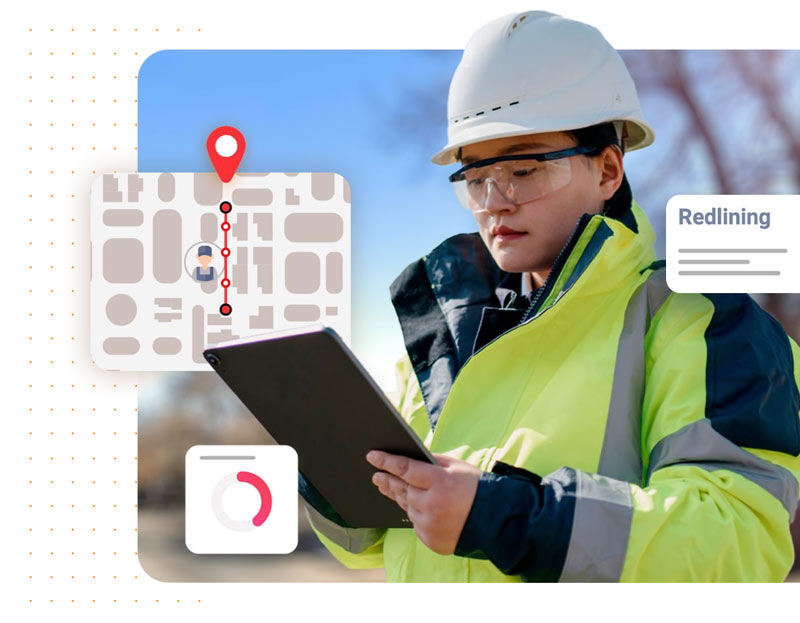
Offline mobile GIS redlining
Provide the best possible support to field activities, relying on a rich work package of GIS visualizations to use while offline. Technicians can view the detailed structure of plants (including specific information and multimedia attachments about the asset to maintain) and consult geographic data and maps in offline mode with a high level of configurability. Moreover, they can choose the best view based on the type of layer or work.
Network tracing
Gain a detailed network model of asset flow within utility networks, providing essential insights into electricity substation and water utilities infrastructure.
- Seamless integration with Esri’s tracing tools
- Three tracing modes
- Cutting-edge map visualization
- End-to-end decision making
Mobile GIS offline extension
Provide comprehensive GIS capabilities to field teams, ensuring smooth transitions between cloud environments and desktop applications, even when offline.
- Extensive GIS visualizations
- Support for multimedia attachments
- Configurable viewing options


Unlock the full potential of GIS Capabilities with industry best practices!
Download the ebook to understand the full strategy to migrate to Esri’s Utility Network.
What is Geographic Information System (GIS) networking?
Geographic Information System (GIS) networking refers to the integration and sharing of geographic data and spatial analysis among various stakeholders, including government agencies, businesses, and academic institutions. By connecting GIS technologies and databases, organizations can collaboratively analyze and visualize spatial information, allowing for improved decision-making and problem-solving. This networking facilitates real-time data sharing, enhances resource management, and supports collaborative projects such as urban planning, environmental monitoring, and disaster response. Ultimately, GIS networking fosters a more informed community by making geographic insights accessible to a wider audience, promoting transparency and efficiency in diverse applications.
What is GIS utility network?
A GIS (Geographic Information System) utility network is a framework that allows organizations to model, analyze, and manage the infrastructure of utility systems such as water, gas, and electricity. This network enables utility companies to integrate various data sources and provide a real-time visualization of their assets, helping them to identify relationships and dependencies within their infrastructure. By leveraging spatial data and advanced analytics, GIS utility networks facilitate efficient operation, maintenance, and planning of utility services, ultimately leading to improved service delivery and customer satisfaction. These systems are essential for informed decision-making, enhancing resource management, and supporting sustainable development in urban and rural environments.
What is an example of a utility network?
A utility network refers to a system that manages the distribution and supply of essential services such as water, electricity, gas, and telecommunications. An example of a utility network is the water supply system in a city, which includes a wide range of components such as reservoirs, pump stations, pipelines, and treatment plants. This network ensures that clean, potable water is delivered from the source to households and businesses, while also incorporating mechanisms for monitoring usage, detecting leaks, and managing pressure. By utilizing advanced technologies like smart meters and geographic information systems (GIS), utility networks can enhance efficiency, reduce waste, and ensure reliable service for the community.
How is GIS used in utilities?
Geographic Information Systems (GIS) play a crucial role in the utilities sector by enabling the effective management, analysis, and visualization of spatial data related to infrastructure, resources, and service delivery. Through GIS, utility companies can create detailed maps that depict the location of assets such as power lines, water pipes, and gas distribution networks, which aids in maintenance and planning efforts. Additionally, GIS helps in assessing environmental impacts, optimizing service routes, and responding to outages or emergencies with greater efficiency. By integrating GIS with other systems, utilities can enhance their decision-making processes, improve operational efficiency, and ultimately deliver better services to their customers.