
Esri Utility Network and OverIT together to reshape GIS asset management software

The management of linear assets, such as power lines, telephone lines, gas pipelines, fiber connections, roads, and railways, entails a mission for Energy and Utilities, Telecommunications, and Transportation companies: to constantly keep the network up and running. The depicted scenario plays its key role in guaranteeing 100% service continuity while ensuring employee safety and customer satisfaction. On top of this is the goal of achieving zero emissions by 2050.
To ensure this, operators need to modernize and simplify the processes of maintaining and extending their networks. Esri Utility Network is becoming the standard in technology network modeling, as it provides tools for data quality assurance and advanced analysis of the effects of outages and planned maintenance activities on networks.
In addition, OverIT’s GIS (Geographic Information Systems) solution offers several methods to enable organizations to accelerate the process of data migration to Utility Network, such as by editing the network from the web. Moreover, the advanced integration with NextGen FSM, OverIT’s Field Service Asset Management software, allows to tailor the built-in visualization, editing, and analysis capabilities of Esri technology to specific maintenance processes.
OverIT’s solutions are the result of more than 20 years of experience in the FSM industry, which makes OverIT the trusted partner for companies managing linear assets. Four strong differentiators form the basis of its commitment:
- Primary focus on linear assets: the platform integrating GIS and FSM is not a generic cross-industry solution, but a product designed for utilities and linear asset management.
- 100% FSM orientation: OverIT is entirely dedicated to supporting mission-critical operations.
- Full adherence to local regulations: understanding this is a strategic element in the industry, OverIT places the utmost importance on monitoring compliance.
- Development of enterprise-level solutions: OverIT implements products specifically designed for large companies managing complex processes.
Benefits of GIS in Field Service Management
The imperative for organizations that manage linear assets can be summarized as follows:
- Responding promptly to emergencies to minimize the duration of service interruptions.
- Preventing breakdowns, leaks, and environmental disasters.
- Giving field technicians and field teams access to the most accurate data at all times, even when connectivity is not available.
- Designing, estimating, and implementing network edits and extensions, displaying data (e.g., contracts, firms, networks, assets) in a single view for faster and more efficient processes.
To meet these needs, about 70% of organizations managing linear assets have digitized their network through GIS software and rely on the use of GIS data in the field. However, GIS alone is not enough to support organizations in improving their ability to quickly manage emergencies and prevent disruptions and accidents.
Despite this, less than 20% of the above-mentioned organizations have integrated GIS capabilities within their FSM solution. This represents the gap to be bridged.
By adopting an FSM software, companies can:
- Maximize the efficiency of asset utilization.
- Increase network reliability and availability.
- Improve security levels by extending the asset lifecycle.
These goals can only be achieved by displaying GIS data within the FSM solution in order to be virtually more effective in managing maintenance activities, both when planning and assigning them to field teams and monitoring their progress, and when executing activities in the field.
Nevertheless, this still leaves an issue to be solved. An FSM software is by nature highly operational, decision-oriented, and designed for users who must accomplish their own mission, which is, as said before, keeping the network running. Instead, GIS capabilities are critical in many maintenance processes but require users to have a certain degree of familiarity with geographic data management. How to provide the FSM system with a view of the network that is accurate, always up-to-date, constantly available even in the field, and editable, if necessary, to achieve 100% integration of FSM and GIS?
Collaborative Approaches in GIS Integration
To ensure the highest efficiency of FSM processes, OverIT combines three aspects:
- The use of Esri technology, with Esri Utility Network as the core element.
- The supply of its GIS solution tailoring the functionality provided by Esri components to specific business processes.
- The integration of GIS capabilities within NextGen FSM, OverIT’s FSM product.

Why Esri Utility Network
This article does not aim to detail Esri technology and its solution Utility Network, but to briefly address the reasons why the Utility Network data model is emerging as a benchmark for the sector.
Firstly, it provides dedicated modules to serve different network types (i.e., water, electricity, gas) and can be further adapted to meet specific needs.
Secondly, it enables the definition of connectivity rules, thus guaranteeing network integrity. From the functional point of view, this offers many benefits in terms of:
- Reproducing real-world behavior when defining network features.
- Highlighting the connections between different network components.
- Tracking water, electricity, and gas flows through the network.
- Providing a view of the operating status and configuration of all mobile devices in the network.
- Simulating the impact of external events on network operation.
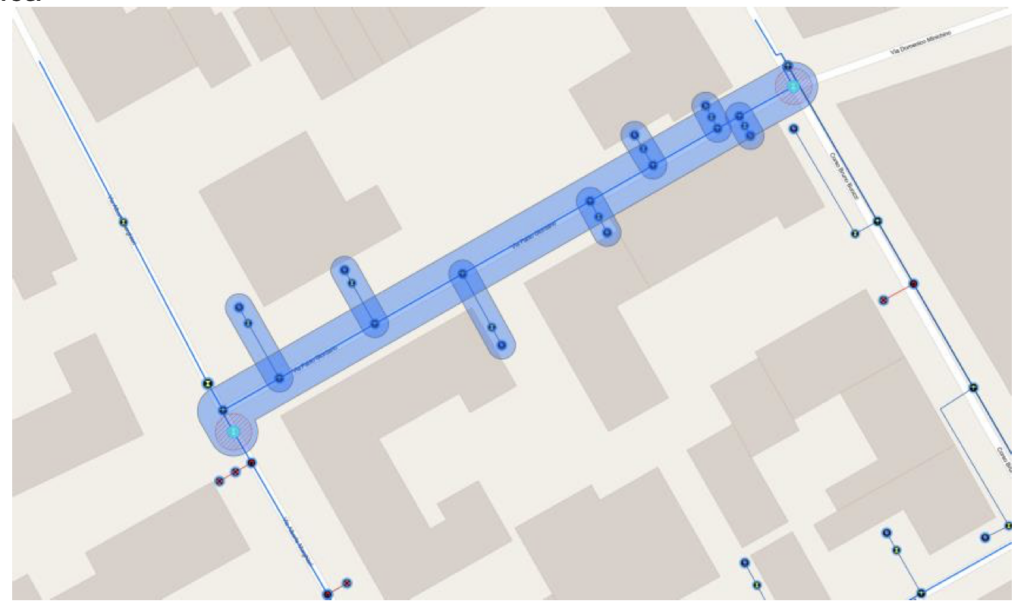
Finally, the possibility to update data through standard services facilitates the integration of editing capabilities within the GIS solution. This proves particularly useful to edit data directly from the web and consequently limit the use of desktop applications to those situations where massive editing is needed (e.g., new plots and/or acquisitions of other companies’ networks).
The GIS solution
In order to transform the GIS solution for companies to benefit from the adoption of the Utility Network data model, the following activities taking into consideration the as-is situation are necessary:
- Assessment of the current system and requirement analysis.
- Preparation of the Proof of Concept, if required.
- Design of the data model to include network management rules.
- Implementation of procedures to migrate data to the Utility Network model and check integrity and automatically correct errors.
- Configuration and customization of the GIS solution to suit specific business needs by also integrating with other enterprise systems.
OverIT’s GIS solution is based on a common framework, which provides the user with a web interface enabling navigation, search, query, and reporting activities to visualize and update the network, as well as analyze its interaction with the territory. Most importantly, the framework relies on Esri Utility Network services to update the network in case of extension, modification, and dismantling activities via web interface.
At the same time, the integration within the GIS solution of different information layers allows to perform analysis on the maintenance activities: a classic example is the monitoring of areas subject to hydrogeological risks to identify assets at risk and plan inspections in the field to verify the actual asset conditions.
The GIS integration within the FSM solution
The integration with GIS provides a cartographic view of the assets, enabling even users without specific GIS skills to dynamically plan and optimize asset maintenance activities by precisely locating the assets to maintain and automatically or manually assigning planned and emergency activities to field techs, according to geographic proximity criteria.
Specifically for field operations, asset location via mobile app allows field personnel without particular GIS skills to intuitively and quickly access geographic data by easily locating the position of assets even when they are not visible, gathering information from the map, performing redlining activities, and updating information on the network being maintained or built. A key added value is the ability to consult GIS data via mobile app even when connectivity is absent.
Innovative Applications of GIS in Field Service
OverIT’s GIS solution handles a number of use cases requiring the integration of NextGen FSM and Esri technology. Moreover, many of these register benefits from adopting the Utility Network data model:
- Design and upgrade of networks.
- Maintenance schedules, assignment, and debriefing urgent and planned activities in the field.
- Management of planned outages and breakdowns.
- Preparation of estimates and implementation of new connections.
- Monitoring the asset in real time.
By integrating the digitized network with enterprise or external information layers, users can also analyze asset interactions with the territory. Below are some additional use cases, which will not be further detailed in this article:
- Asset classification according to hydrogeological risk to better plan both the inspections assessing the actual infrastructure assets conditions with respect to risk and the consequent execution of enhancement and preventive maintenance activities.
- Analysis of satellite imagery also through Artificial Intelligence algorithms to identify potential interference of the newly designed network with human-made elements present along the network.
The following are the main processes managed with respect to designing extensions and changes to the network:
- Organization of the design workflow.
- Update of the design network.
- Estimation of costs.
To manage these processes, the GIS solution offers specific functionality enabling:
- The simplified editing of the network for preparing a general drawing.
- The integration of different types of assets and their attributes in the design layer.
- The editing validation by relying on the rules defined on the Utility Network data model.
Thanks to the accurate data entry and the native integrity guaranteed by the Utility Network data model, it is possible to estimate implementation costs and easily export data necessary for fluid dynamics modules.
An important added value is provided by the integration with the BIM methodology:
- While performing the design activity, the BIM system allows monitoring the design progress on different project areas.
- The integration via IFC standard gives the possibility to add the geometric characteristics of the network elements into the GIS data model.
- The 3D view of the network on GIS enables a more effective understanding of its interaction with the territory.
- The 3D view on the mobile app makes it possible to immediately access the location and features of the different network elements.
The following are the main processes managed with respect to the design of extensions and changes to the network:
- Update of the network according to the actual realization.
- Monitoring of field activities constantly.
- Execution of consistency checks on the network.
To manage these processes, the GIS solution offers specific functionality enabling:
- The insertion, modification, and dismantling of network objects on the as-built layer.
- The validation of the data entered by relying on the Utility Network data model rules.
- The management of the work approval process.
In the case of data transmitted with other formats, service integration with the Utility Network data model simplifies writing of the built-in data import procedures.
The same happens when building the network. The native integrity guaranteed by the Utility Network data model streamlines integration with fluid dynamics modules.
Using the mobile FSM component also enables daily reporting of the activities performed and therefore the possibility for supervisors to daily check the progress of the work according to the data entered and the multimedia documents attached to the report. Finally, an important innovative element is the use of Artificial Intelligence algorithms to compare designed and as-built scenarios based on data collected in the field through the FSM mobile application.
The following are the main processes managed with respect to the management of planned maintenance and emergencies:
- Assessment of users affected by the service disruption.
- Planning/execution of field activities.
- Performance of reporting activities.
To manage these processes, the GIS solution offers specific functionality, which can also be integrated within NextGen FSM, enabling:
- The integration with signaling systems (e.g., location identification, georeferencing, network asset association).
- The assessment of users affected by using tracing capabilities applied to the Utility Network data model.
- The planning of field activities based on the position of the different teams (while the FSM solution allows to verify the skills needed by the technicians to perform the activities).
- The support during the activity execution by accessing GIS data on the FSM mobile app (also in offline mode).
- The performance of automated reporting.
In order to increase the process efficiency, the network management of the future requires monitoring and controlling networks and facilities in real time and from remote.
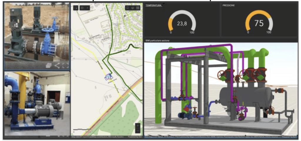
- Integration with GIS and IoT: Map view of the facility status highlighting alarms and giving access to remote control features.
- Remote control: Dashboard monitoring the asset status and allowing to modify operating parameters and/or status.
- BIM integration: 3D view of the facility highlighting specific assets.
The following are the main processes managed with respect to the management of new connections:
- Issuance of quotations.
- Data extraction for contractual purposes.
- Planning, execution, and entry of new connections into the system.
To manage these processes, the GIS solution offers specific functionality enabling:
- The planning and execution of prior inspections in the field by also relying on Virtual Collaboration tools.
- The use of Virtual Collaboration and AI tools for cost estimation activities.
- The automatic extraction of data for contractual purposes.
- The planning and execution of connection activities.
- The editing and validation of the network from the web according to the Utility Network data model rules.
Overcoming Challenges in GIS Integration
The introduction of OverIT’s FSM+GIS solution and the simultaneous adoption of the Utility Network data model, brings significant benefits to organizations:
When it comes to design activities:
- Simplification of procedures and reduction of information flows when editing the designed network.
- Increase of accuracy in designing the network also in view of future consistency checks between planned and actual realization.
- Decrease of constraints to meet when selecting suppliers in the case of BIM integration.
- Adherence to future regulatory obligations in the case of BIM integration.
When it comes to implementation activities:
- Simplification of editing activities and reduction of information flows when editing the as-built network by also engaging contractors.
- Monitoring of construction activities in real time.
- Increase of accuracy and integrity of the network for executing maintenance activities.
When it comes to the management of planned outages and emergencies:
- Increase of accuracy when assessing users impacted and producing related reports.
- Reduction of response times.
- Compliance with regulatory requirements.
- Decrease of inspections and field activities, while saving costs in the case of IoT integration.
- Increase of safety in the case of IoT integration.
When it comes to new connections:
- Improvement of accuracy of estimates.
- Simplification of editing activities and reduction of information flows when editing the network by also engaging contractors.
- Compliance with SLA.
GIS Director at OverIT, responsible for guiding the strategic direction and implementation of GIS systems to optimize business processes and maximize operational efficiency. Expert in coordinating complex projects, he excels in developing innovative and high-quality solutions that meet customer needs. His extensive experience in managing multidisciplinary teams, drives his commitment to promoting technological innovation, making the most of the latest in spatial analysis to lead the company towards success.